Your search results

20.18 Acres in Tennessee with Water Well, Power, Fiber Internet, Road Access & Mature Trees

$ 141,080

Property details

LANDIO Property ID
TN_Stewart_00070
Price
141080
Parcel Size
20.18Acres +/-
Address
Cox Hollow Road
Zip
37058
Parcel Number
-
Current Zoning
Forest
General Elevation
520 - 640 feet
Taxes
$832 per year
Conveyance
Warranty Deed
Sewer
Septic (not installed)
State
Tennessee
County
Stewart
City
Dover
GPS
36.435833, -87.932551
Title
Free & Clear
Access
Cox Hollow Road
Terrain
Gently Rolling
HOA Fees
None
Water
Water Well (not installed)
Phone
Cell or Satellite
Power
Along the Property

Description

Property Description

This Property (Lot 15) has a newly installed Water Well.

FREEDOM RIDGE @ Dover is ideally situated between Kentucky Lake and Lake Barkley, while also being less than 3 miles from the South boundary of the 170,000 Acre Land Between the Lakes National Recreation Area.

ALL Lots in FREEDOM RIDGE @ Dover have Road Access, Mature Trees, Power and High-Speed Fiber Internet.

There is NO HOA or HOA Fees.

There is also NO Time-Limit to Build. You can start breaking ground upon your purchase  or leave the land vacant for generations.

You may use the Property Recreationally, Seasonally or Live There Full-Time.

You can build your Dream Home, Tiny Home, Cabin, Barndomium or use one of the many pre-fabricated options that can be delivered to your Lot virtually ready-to-go.

You may build multiple structures on your Lot including additional Cabins or Homes, Workshops, Barns, Corrals, Greenhouses, Studios, Treehouses or whatever your imagination desires.

For Recreational Use, consider pitching a Tent, Teepee or Live in an RV…all are possible at FREEDOM RIDGE!

Horses, Donkeys, Goats, Cows, Chickens and other Animals and Livestock can roam your Land.

When it comes time to develop your Lot, Water can be handled by drilling a Water Well and Sewer by installing a Septic System.

Multiple Water Wells have been successfully drilled within FREEDOM RIDGE @ Dover.

The FREEDOM RIDGE Team can provide you with a list of Licensed Water Well and Septic Contractors in the area. For this information, Call or Text the FREEDOM RIDGE Team Anytime at: 615-437-3124

Hunting

Whether on your own property or a nearby public hunting area, Northern Tennessee is an excellent region for seasonal game hunting of White-tailed Deer, Wild Turkey, Waterfowl and Small Game. Find hunting locations and license/permit info here.

Fishing

No matter your fishing style, shoreline, boat, river, and lake fishing are all within reach.

To the East, the 688-mile Cumberland River widens to form Lake Barkley. This historic river has long supported riverboat trade and travel. Today, it draws many hunters, anglers, and outdoor enthusiasts to its thriving waters and banks. Massive Striped Bass, Rainbow Trout, Brown Trout, Walleye, Sauger and Catfish flourish within the river.

To the West, the Tennessee River widens to form Kentucky Lake.

Kentucky Lake is known for trophy-winning Largemouth Bass, Bluegill, Redear, Crappie and Catfish. FREEDOM RIDGE @ Dover is 9.1 miles from Gray’s Landing, which has the closest boat ramp to access the Kentucky Lake. Get more info here.

Recreation

Kentucky Lake, Lake Barkely and the Land Between the Lakes National Recreation Area consists of over 170,000 Acres of publicly accessible forests and open lands. This includes over  300 miles of undeveloped shoreline, 200 miles of paved roads, and over 500 miles of trails.

 The Land Between the Lakes is an idyllic setting for Camping, Picnicking, Hiking, Fishing, Boating, Wildlife Viewing and Water Sports. Licensed hunts for White-tailed Deer, Turkey, Squirrel and other small game animals occur throughout the year.

FREEDOM RIDGE @ Dover is 7.9 miles from the South Welcome Station at Land Between the Lakes National Recreation Area, with many trailheads throughout Dover. Book a guide or plan your adventure. Learn more about Tennessee’s best outdoor recreational gems here.

Nearby Town & Cities

While FREEDOM RIDGE @ Dover offers peace, privacy and tranquility, it’s close what you need.

Dover, TN

The City of Dover, is just 7.2 miles to the Northeast. Situated along the Cumberland River, Dover  has a population a little under 2,000.

In Dover  you will find a Piggly Wiggly Grocery Store, Hardware Store, Dollar General Pharmacy, Post Office, Restaurants, Professional Services and School.

Clarksville, TN

The City of Clarksville, is just 38 miles to the Northeast. Clarksville is the 5th Largest City in the entire State of Tennessee, but still maintains an air of small town feel due to its rich history. Also situated along the Cumberland River, Clarksville  has a population of around 180,000.

In Clarksville, you’ll find pretty much anything you need including a hospital, Home Depot, Lowe’s, Sam’s Club, Target, Walmart, several Grocery Stores, Restaurants, Entertainment and Professional Services.

The Clarksville Farmer’s Market was Voted the Best Farmer’s Market in all of Tennessee in 2023.

Just outside of Clarksville is Fort Campbell. Comprising of nearly 100,000 Acres, Fort Campbell supports the 4th largest military population in the Army and the 7th largest in the Department of Defense. Fort Campbell is home to the 101st Airborne Division, also known as the Screaming Eagles.

Nashville, TN

Nashville, the State Capital and Largest City in Tennessee, is 88 miles from FREEDOM RIDGE @ Dover. Nashville and the surrounding metropolitan area have a population of more than 2,000,000.

Known as the Country Music Capital of the World, Nashville has World-Class Entertainment, Shopping, Dining and Medical Care. Nashville also has an International Airport with direct flights to and from most major Cities.

Property Specifications

FREEDOM RIDGE @ Dover Lot 15

LANDIO ID: TN_Stewart_00070

Price: $141,080

Parcel Size: 20.18 Acres +/-

Property Taxes: $832 per year

HOA Fees: None

Road Maintenance: There is a Road Maintenance Agreement where ALL Property Owners contribute a $500 one-time fee and then $25 per month to cover ongoing maintenance of nearly 5 miles of roads throughout FREEDOM RIDGE @ Dover

General Elevation: 520 – 640 feet

Title: Free & Clear

Conveyance: Warranty Deed

Distances to Nearby Cities & Points of Interest

*Approximate Distances from entrance of FREEDOM RIDGE @ Dover

7.1 miles to Dover City Boat Ramp on Cumberland River (more info)

7.2 miles to Dover, TN : Population 1,825 (more info)

7.9 miles to Land Between the Lakes National Recreation Area (South Welcome Station) (more info)

9.1 miles to Kentucky Lake (more info)

9.1 miles to Gray’s Landing Boat Ramp on the Kentucky Lake (more info)

10.9 miles to the Cross Creeks National Wildlife Refuge (more info)

11.1 miles to Stewart State Forest (more info)

38 miles to Clarksville, TN : Population 180,000 (more info)

48 miles to Hopkinsville, KY : Population 31,000 (more info)

88 miles to Nashville, TN : Population 2,000,000 (more info)

Visiting the Property

To Schedule a Tour of the Property, Please Contact the FREEDOM RIDGE Team Anytime by Call or Text at: 615-437-3124

Interactive Map of Lot 15 (View Map)

The Interactive Map linked below shows the Status of Each Lot. Green = AVAILABLE, Yellow = UPCOMING, Purple = PENDING, Red = SOLD

View the Interactive Map showing ALL 70 Lots

GPS Coordinates (approximate)

Lot 15 Center Point: 36.435833, -87.932551 (Google Map)

Entrance to FREEDOM RIDGE @ Dover off of Cox Hollow Road: 36.447136, -87.926770 (Google Map)

Contact Information

For Questions or to Purchase this Property, Please Call or Text the FREEDOM RIDGE Team Anytime at: 615-437-3124

You may also Email the FREEDOM RIDGE Team at: hello@freedomridge.com

Please Reference: FREEDOM RIDGE @ Dover Lot 15

This Property is 1 of 70 Tracts of Land for Sale being offered in FREEDOM RIDGE @ Dover

The Interactive Map linked below shows the Status of Each Lot. Green = AVAILABLE, Yellow = UPCOMING, Purple = PENDING, Red = SOLD

View the Interactive Map showing ALL 70 Lots

Property to Sell? Visit: SELLwithLANDIO.com

Feature Your Listing on LANDIO at: LANDIO.com/feature

To Speak with LANDIO, Call or Text Us Anytime at 866-8-LANDIO (866-852-6346)

Overview

  • Updated On:
  • August 20, 2025

We use a mapping program called Land ID. The free Land ID app for land scouting should be downloaded to your phone before you go. The map can also be saved to make life easier for you. You will see below that we have links for the Land ID app that will work on most smartphones. Land ID will show you the parcel outlines on the satellite view when you are at the property and we would not scout properties without it. Please ask us if you need help!

Download The Land ID App For Android Or iPhone

Have a Question About This Property?

Similar Listings

Available

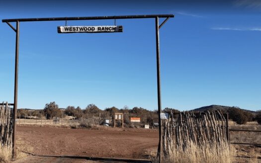
40 Acres of Secluded Property in Westward Ra...

$ 40,000 $45,000.00
This beautiful, picturesque desert property is located in Williams, Arizona in the 140,000 ...
acreage55 acreagedetailsCountyArizona
Finance Terms : N/A / now Not Offered
Available

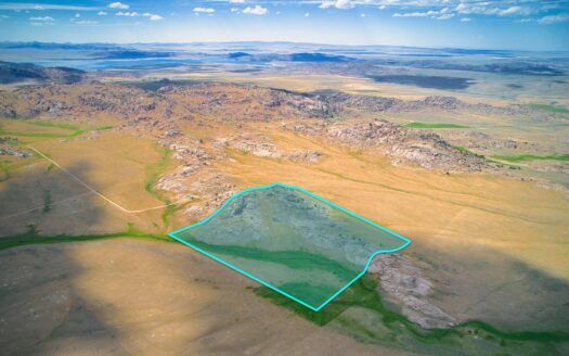
40 Acres with Creek & Mountain Views bor...

$ 164,997 $164,997.00
40 Acres with Mountain Views bordering State Land near Pathfinder Reservoir Don’t miss thi ...
detailsCountyWyoming
Available

40 Acres with Power, Road Access & Bord...

$ 159,900 $159,900.00
Property Description 40 Acres with Road Frontage, Power, Rock Formations, Open Pastures &a ...
detailsCountyWyoming

Schedule a tour

Sat 06 Sep
Sun 07 Sep
Mon 08 Sep
Tue 09 Sep
Wed 10 Sep
Thu 11 Sep
Fri 12 Sep
Sat 13 Sep
Sun 14 Sep
Mon 15 Sep
In Person
Video Chat
Your information

Compare Listings

Get a Free Land Buying Guide

Get exclusive access to land deals before they hit the market